Import trajectory process
SatGen 4 has the ability to load an imported file for the simulation trajectory – supported trajectory file formats are:
- NMEA file
- KML file
- VBO file
- CSV file
To import one of these files into SatGen 4, select the ‘Import’ icon within the tool bar at the top of the software window.

This will open the import view below where you can select which format you want to load.
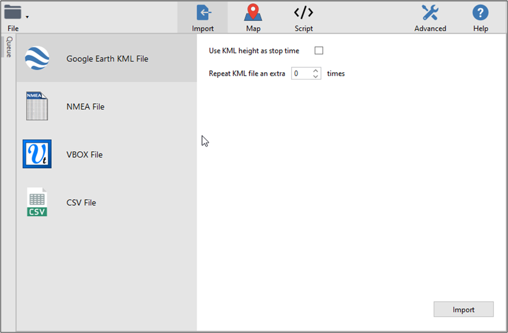
If you are importing a KML, NMEA or CSV file you will be present with specifics parameters to select for the file format before importing – these are detailed below.
KML File options:
- Use KML Height as stop time – Tick this box to make SatGen 4 use the KML height in the file as the stop time.
- Repeat KML file an extra X times – You can decide to make SatGen 4 repeat the KML file up to 99 times. Use the up and down arrows to adjust the value.
NMEA File options:
- Smooth NMEA data – Tick this box before you load the NMEA file to enable the NMEA data smoothing.
- Smoothing level – You can adjust the NMEA smoothing level with the up and down buttons next to the level value.
CSV File options:
Note: Latitude and Longitude fields are required while Altitude and Delay fields are optional.
- Delimiter – Select the delimiter used in the .csv file. Your options are:
- Comma
- Colon
- Equals Sign
- Semicolon
- Space
- Coordinates Format – Select the coordinates format applicable to the .csv file you want to import. Your options are:
- Degrees
- Radians
Overview
The SatGen software allows you to create a GNSS RF I&Q or IF data file based on a user-generated trajectory file that you can replay on a LabSat GNSS Simulator.
SatGen is a great tool to use when you wish to test your device in locations that you’re unable to visit, including hostile environments and areas with strict travel restrictions. It also eliminates the cost and inefficiency of performing multiple field tests and it allows you to test at any point in time, past or future. You can create scenarios to test specific product attributes, such as geofencing, and you can add timed stops to simulate multi-stop routes.
SatGen compliments the LabSat range of GNSS simulators and is available in single, dual, triple, multi-frequency/multi-constellation and Real Time versions.
The SatGen software comes with the following configurations:
- Single Constellation – This version allows for easy generation of data into LabSat scenario files for replay with LabSat, LabSat 2 or LabSat 3 simulator systems. The software will create a single constellation file for GPS L1, Galileo E1, GLONASS L1 or BeiDou B1.
- Dual Constellation – This version allows for easy generation of data into LabSat scenario files for replay with all hardware versions of LabSat simulator systems. The software will create single or dual constellation files for GPS L1, Galileo E1, GLONASS L1 or BeiDou B1 in any two or single-constellation combination.
- Dual Constellation – Real Time – This version allows for easy generation of data into LabSat scenario files for replay with all hardware versions of LabSat simulator systems or Real Time output. The software will create single or dual constellation files for GPS L1, Galileo E1, GLONASS L1 or BeiDou B1 in any two, single constellation combination or a live signal stream to a LabSat RT with less than a 1-second’s latency.
- Triple Constellation – This version allows for easy generation of data into LabSat scenario files for replay with all hardware versions of LabSat simulator systems. The software will create three, two or single constellation files for GPS L1, Galileo E1, GLONASS L1 or BeiDou B1 in any constellation combination.
- Wideband – This version allows for easy generation of data into LabSat scenario files for replay with all hardware versions of LabSat simulator systems. The software will create triple, dual or single constellation files for GPS L1, Galileo E1, GLONASS L1 or BeiDou B1 in any constellation combination for all LabSat variants or GPS L1C/A, L1P, L1M, L2C, L2P, L2M, L5I, L5Q, Galileo E1, E5a, E5b, E6, GLONASS L1OF, L2OF, BeiDou B1I, B2I, B3I, NavIC SPS L5, SPS S, in LabSat 3 Wideband format only.