“Achieve Centimetre level Accuracy – Instantly, Everywhere”
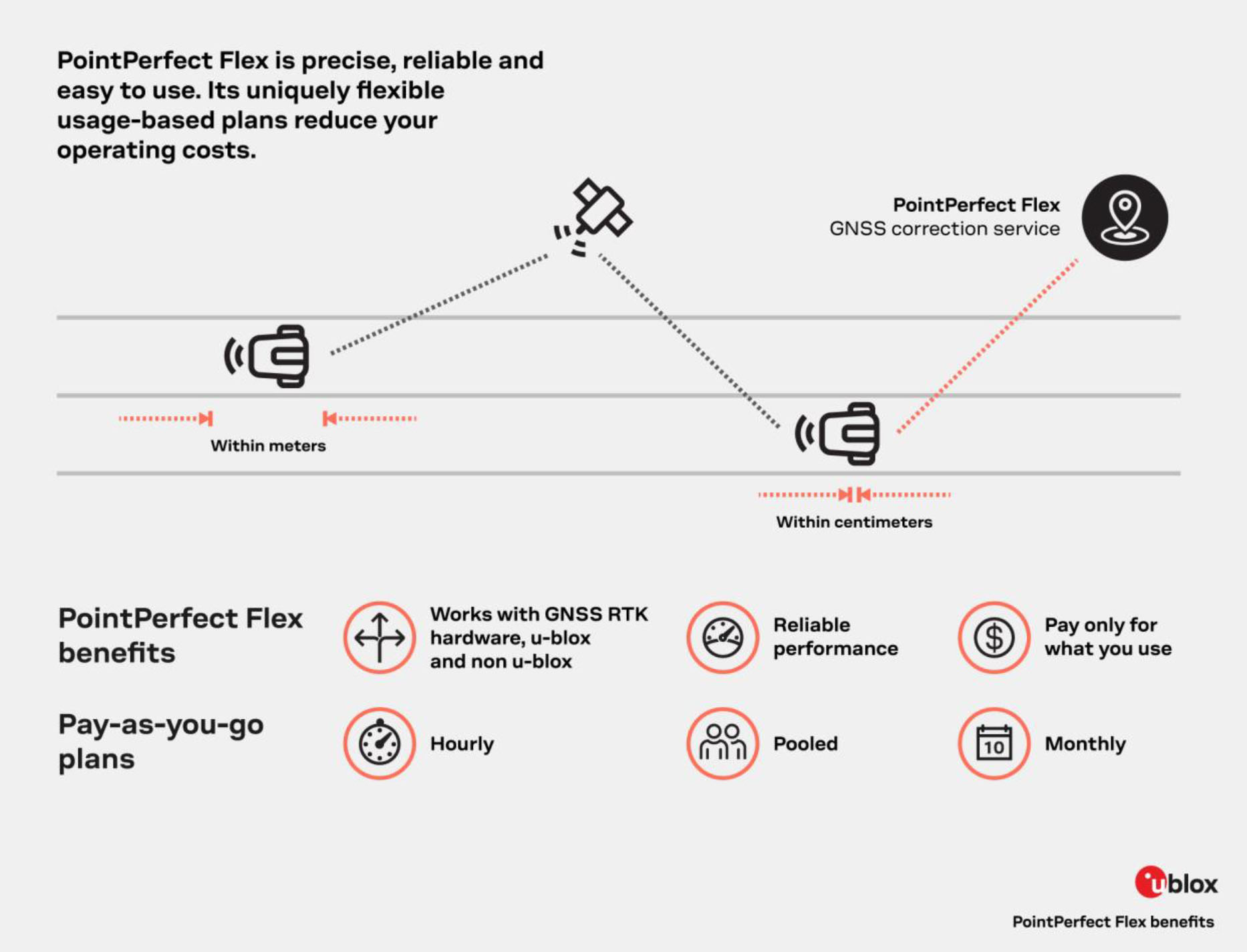
PointPerfect Flex is u-blox’s cutting-edge PPP-RTK GNSS augmentation service, designed to deliver real-time, centimetre-level positioning with unparalleled coverage, efficiency, and ease of integration.
Why PointPerfect Flex Matters
- Real-time centimetre precision: Combine the best of RTK and PPP to converge to centimetre-level accuracy in seconds, even for mobile or dynamic applications.
- One broadcast, many users: A single correction stream can be shared by many receivers, reducing infrastructure overhead and scaling effortlessly.
- Wide-area, continental coverage: Uniform coverage across large geographies (including up to 12 nautical miles offshore) ensures consistent performance without regional fragmentation.
- Low bandwidth, high efficiency: Uses the SPARTN standard data format to minimize data transmission costs and support battery-constrained or bandwidth-limited systems.
- Flexible delivery methods: Supports both IP (Internet) and satellite L-band channels, plus compatibility with NTRIP for easy adoption.
- Seamless integration & open ecosystem: Works with u-blox’s silicon-to-cloud stack — receivers, hardware, software — yet also supports hardware from other vendors, thanks to its open architecture.
- High reliability: Engineered for 99.9 % availability, backed by expert support and infrastructure resilience.
- Flexible licensing plans: Usage-based options let you scale with your business, without overcommitting to rigid contracts.
Ideal Use Cases
PointPerfect Flex is perfect for sectors and applications where real-time, ultra-accurate positioning is critical:
- Autonomous vehicles & ADAS – lane-level navigation, automated steering support
- Drones & unmanned systems – precise flight paths, accurate geo-tagging, reliable control
- Robotics & automated machines – repeatable trajectories, high positional fidelity
- Precision agriculture – machinery guidance, field operations, resource optimization How It Works (At a Glance)
How It Works (At a Glance)
- The network models GNSS error sources (clocks, orbits, ionosphere, troposphere) across broad areas.
- Correction data is broadcast via IP or L-band to your device.
- The GNSS receiver computes localized corrections from the broadcast model, applying them to its observations.
- You get centimetre-accurate positioning, with fast initialization and no need for a nearby base station
Technical Specification
Data Format | SPARTAN 2.0 | RTCM 3.3 |
Technology | Advanced PPP-RTK (SSR type) | Advanced PPP-RTK (OSR type) |
Horizontal accuracy¹ (2-sigma 95%) | 3 – 6 cm | 3 – 6 cm |
Initialization time (depends on ionospheric activities) | 10 – 30 seconds | 10 – 30 seconds |
Coverage | Regions of the Americas, Europe, Asia, and Australia. For latest coverage details see here | |
Reference frame | ITRF2020 current epoch | ITRF2020 current epoch |
Data rate | 0.5 Kbits per seconds 2.4 Kbps for L-band satellite | 4 – 6 Kbps RTCM format is not provided via L-band satellite |
Standard correction rate | Satellite clock: 5 seconds Satellite orbs, bias & atmosphere: 30 seconds | 1 second |
GNSS signal support | GPS: L1 C/A, L2P, L2C, L5 Galileo: E1, E5a, E5b BeiDou: B1I, B1C, B2I, B2A Glonass: G1 C/A, G2 C/A | GPS: L1 C/A, L2P, L2C, L5 Galileo: E1, E5a, E5b BeiDou: B1I, B1C, B2I, B2A Glonass: G1 C/A, G2 C/A |
Communication methods | Mobile internet: NTRIP L-band satellite: regionally in South America | Mobile internet: NTRIP |
1: Horizontal accuracy: Typically, 3-6 cm with a compatible receiver. All accuracy results are based on:
a) error-free GNSS observation data
b) receiving complete and uninterrupted correction data
c) ambiguity-fixed position result
For further details and pricing information about the UBLOX PointPerfect solution,
Contact Sampson Technology – we will endeavour to supply the best solution.